
Project
Access to Healthy Assets & Hazards (AHAH) | CDRC Data
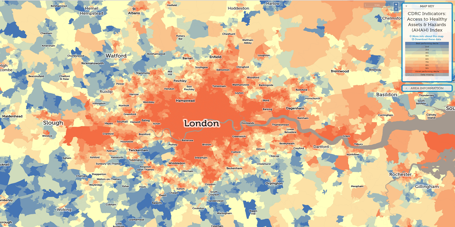
AHAH is a multi-dimensional index developed by the CDRC for Great Britain measuring how ‘healthy’ neighbourhoods are.
University of Liverpool Faculty of Science and Engineering

A University of Liverpool research team led by Dr Mark Green, in collaboration with Professor Alex Singleton and the Consumer Data Research Centre (CDRC), have developed Access to Health Assets and Hazards (AHAH), a unique multi-dimensional index that is designed to better understand the relationship between local geography, the natural environment and how it can influence public health issues.
Our daily purchases, use of social media and travel patterns create a flood of consumer data every day. However, it is not only businesses that can benefit from this information. When linked together from multiple sources, this data can help solve pressing public health issues and reveal how our environment influences our behaviour and health – for the better and worse.
AHAH is an Open Source data index that summarises qualities of neighbourhoods across Great Britain. It provides an open set of indicators, translating consumer data (from loyalty cards and other sources) into insights that can help local authorities understand how to design healthier and more pleasant living environments. The index is linked with health data from local communities and is based on 15 measures across three domains:
The high-quality processed data has been freely available to download since June 2017 and is provided as an interactive map.
The AHAH project has made a range of difficult to access consumer data readily available, processing and linking multiple sources into a user-friendly and meaningful interface. Data can be accessed through a set of open access tools that facilitate innovative interventions by researchers, local governments and policy makers.
The wealth of consumer data has opened a new way to pinpoint hotspots and causes of these health challenges, such as a high density of fast-food outlets or polluting main roads.
The multi-dimensional index allows decision makers to understand real-world factors that determine if a living environment is verging toward ‘healthy’ or ‘unhealthy’, rather than surveying aspects in isolation.
The AHAH tool has been incorporated into Public Health England's 'Wider Determinants of Health' FingerTips data resource, which is used by all local governments in England.
Our research, in conjunction with the Consumer Data Research Centre and Public Health England, has allowed us to pull together freely available information from sources such as GP surgeries, Health Centres, fast food outlets, air pollution statistics published by the Environment Agency. Our updated data release makes it now the most comprehensive free source of data on healthy environments available. The statistics reveal important insights about the concentration of certain amenities that may be damaging or promote health. For example, on average, individuals in Great Britain are just as close to a pub or bar, as they are to their nearest GP (1.1 km). We also found that 42% of people are within 1 km (or a few minutes’ drive time) of their nearest gambling outlet. These statistics reveal troubling issues with the neighbourhoods we live in and how they may be damaging to our health. We anticipate that this resource will be an important tool for citizens and policy makers alike interested in how their neighbourhoods may be associated to their health.
AHAH is a multi-dimensional index developed by the CDRC for Great Britain measuring how ‘healthy’ neighbourhoods are.
The AHAH tool has been incorporated into Public Health England's 'Wider Determinants of Health' FingerTips data resource.